It has taken a long while in our modern society for the notion to take hold that some of the best solutions to reduce the impact of natural hazards can be found in nature itself. Perhaps it is the high cost of continuing to use highly engineered solutions to protect development that has often been sited unwisely in the first place that has finally gotten our attention. Particularly after Hurricane Sandy, however, the notion of using green infrastructure as part of the hazard mitigation strategy for post-disaster recovery began to gain traction; green infrastructure was highlighted in the federal Hurricane Sandy Rebuilding Strategy. These approaches are also known as natural or nature-based designs. They involve understanding the role natural systems play in reducing damages and in using that knowledge to deploy such solutions as part of an intelligent game plan for improving community resilience.
But where should community planners and local officials get reliable information on the best and most proven strategies for implementing green infrastructure solutions?
About a year and a half ago, researchers from The Nature Conservancy (TNC) approached me about involving the American Planning Association (APA) Hazards Planning Center in a project they were undertaking with support from the Kresge Foundation to prepare such information in the form of a green infrastructure siting guide. In the end, they also involved the Association of State Floodplain Managers (ASFPM), the National Association of Counties (NACo), the American Society of Civil Engineers, and the Boston-based design firm Sasaki Associates to assist with this effort. Over the past year or more, we have all met regularly to discuss what needed to be done and our progress in making it happen. We produced case studies, strategy briefs, and other material to populate the project’s web-based resources.
Last month, after all that teamwork, TNC unveiled its new website for the project, called Naturally Resilient Communities. For those interested in knowing how trees, living shorelines, dunes, coastal marshes, and oyster reefs, among other types of natural infrastructure, can help mitigate natural hazards like coastal storms and urban flooding, the website provides a serious and interactive introduction to the subject matter, backed up by numerous resources.
What is especially valuable about the website design is that it allows users multiple avenues into the specific types of information they need. Not all natural infrastructure solutions are born equal. Some are more appropriate in certain settings than others. Some work best in inland river valleys, some along coastlines, and others in mountains or high plains. Some coastal solutions work well in the rocky coastlines of California or Oregon, while others work better along Atlantic or Gulf Coast shorelines. Applying such solutions is largely a matter of learning what works best in a specific natural environment in the face of specific hazards—riverine flooding, hurricanes, thunderstorms, or other threats that communities face. It is critical to adapt the solution to the problem.
Accordingly, the website, largely the work of Sasaki Associates with vetting from the other project partners, allows users to approach the information by deciding which strategies they wish to investigate or which part of the United States is relevant. They can also look at considerations such as cost, the geographic scale of the solution (neighborhood, municipal, regional), and the type of community in question. These are precisely the frames of reference familiar to most urban planners and civil engineers who are most likely to be involved in implementing natural infrastructure projects. The emphasis throughout is on the practical, not the ideal or the ideological. A particular approach either works or does not work, but it does so in very specific settings, such as a neighborhood in a city along one of the Great Lakes or in the Southwestern desert. Context is the central question.

This memorial to Gilbert White, the pioneer of modern floodplain management, marks the high point of flooding along Boulder Creek.
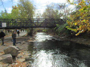
Establishing context is why the project put considerable emphasis on case studies, which cover a variety of communities around the nation. Specify, for example, Rocky Mountain West as a region and riverine flooding as a problem, and the site gives you a case study from Boulder, Colorado, that examines the alternatives considered and solutions adopted for flooding along Boulder Creek and discusses the involvement of the city and the Denver-based Urban Drainage and Flood Control District to implement a stream restoration master plan. One can also find case studies from Florida, Ohio, and numerous other locations. One can also, however, explore sections of the website devoted to additional resources and funding
sources to support green infrastructure projects. These allow the user to connect to other websites and some PDFs for additional information.
Go explore. I admit to taking pride in our involvement in this effort. It is, I think, a welcome resource and great learning tool for planners, engineers, local officials, and the interested public.
Jim Schwab

